


Hurricane Joaquin might just be a no-show this weekend along the East Coast of the United States. The latest tracking maps show the powerful Category 4 storm staying well offshore.
What’s not going away is the rain for the already waterlogged region.
Moisture from Joaquin is being pumped into a weather system stalled along the coast. “We’re looking at historic flooding in coastal South Carolina,” said CNN meteorologist Rachel Aissen. Ten to 15 inches of rain is expected. Charleston, South Carolina, will be especially hard hit, but heavy rain will penetrate all the way inland to Columbia, more than 100 miles away. Gov. Nikki Haley declared a state of emergency in anticipation of major flooding. Friday night football games were moved up a day over flooding concerns in the state’s low country. Others were postponed.
Not just South Carolina
Flood advisories and warnings stretch from North Florida to Connecticut and as far west as parts of West Virginia, Kentucky and Tennessee. The governors of New Jersey and Virginia joined South Carolina in issuing their own states of emergency. Along Virginia Beach’s Atlantic Avenue, a main thoroughfare about two blocks from the ocean, business owners appeared to be taking a wait-and-see approach. There were no boarded-up windows. Stores remained open, but there were only a few customers.
Beach towns in October can be that way.
There was no panic at the Sunsations beach shop. “We’re usually fine here,” said Sharlotte Castillo, “maybe a little rain, but we’re staying open.” Even as far north as Waterbury, Vermont, Skip Flanders was keeping an eye out. He’s seen firsthand from 2011’s Hurricane Irene that the heavy rains from a huge tropical system like this can have devastating effects far from the coast. “We had 28 inches of water in our house from Irene,” Flanders told CNN affiliate WCAX. “I certainly hope that something of that proportion doesn’t happen again.”
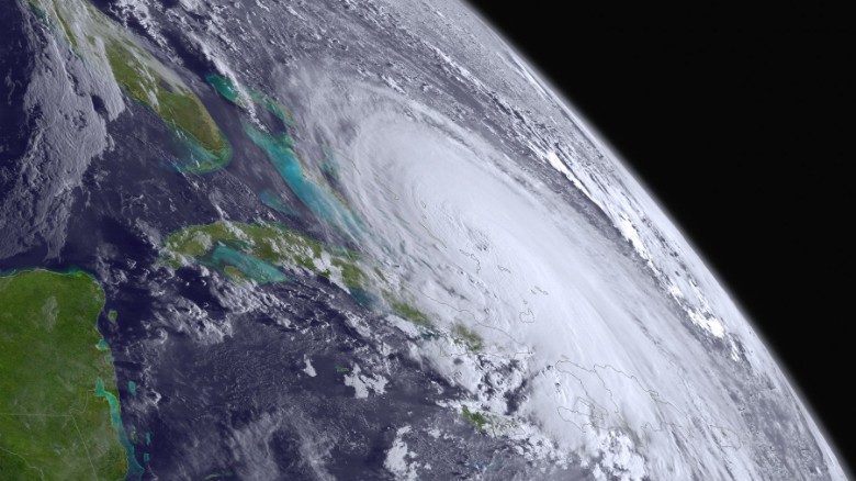
Battering the Bahamas
Early Friday, Joaquin remained essentially stalled over the Bahamas for a second morning. Extensive flooding was reported, with up to three feet of standing water in some areas. Winds are 130 mph. Rainfall totals could hit 20 inches. “We are closely monitoring Nassau now to see where the storm is at first light … since that is where the majority of the population is located,” said Basil Dean of the Bahamas Department of Meteorology. “Freeport, Grand Bahama, Eleuthera and other tourist areas are also being closely monitored.”
Could it still make landfall in U.S.?
Joaquin is expected to begin its trek north later in the day, and while the latest forecast map takes it out into the Atlantic, the unpredictable nature of hurricanes could still bring it back toward the East Coast. But will it? “We’re at the point we still need to stay aware,” Aissen said. “It could still shift.” If it hasn’t made its move by Friday evening, she said, Joaquin will stay out at sea.